

BRINC, the leader in public safety drone technology, today announced two new BRINC LiveOps map layers for live wildfire tracking and real-time smoke coverage. Made available Friday, August 7, to all BRINC customers at no additional cost, the new layers give public safety agencies critical wildfire intelligence directly alongside their existing drone operations.
Built on data from the National Oceanic and Atmospheric Administration (NOAA), the new layers display active fire detections and smoke conditions on the same map agencies already use to manage drone operations, live video, and incident response. Teams can toggle each layer independently to view fire activity, smoke coverage, or both as part of a single operational picture.
The new capabilities give fire departments and emergency managers another source of real-time intelligence as they assess and coordinate wildfire response. They also help law enforcement agencies operating in affected communities maintain situational awareness when smoke and reduced visibility complicate operations on the ground.
“When agencies are stretched thin responding to wildfires, the last thing they need is another screen to check,” said Blake Resnick, BRINC Founder and CEO. “Our customers already run their drone operations in our software. Now fire activity and smoke conditions are right there on the same map. And like every BRINC integration, it’s free.”
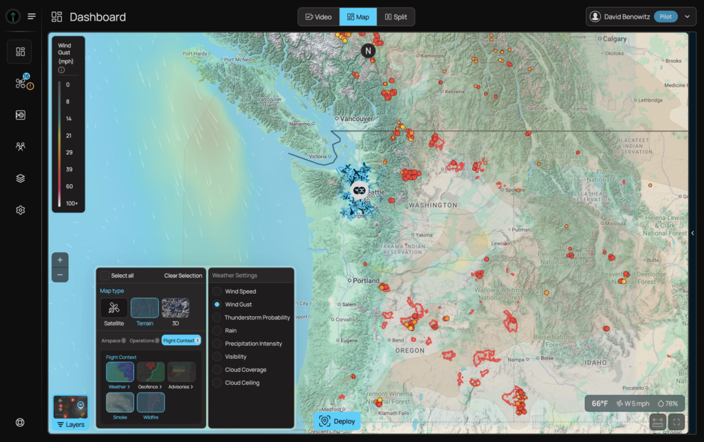
The wildfire and smoke layers reflect BRINC’s broader approach to LiveOps by bringing the information first responders need into a single operational view. Instead of forcing agencies to move between disconnected systems during an emergency, LiveOps brings together drone video, dispatch information, third-party data, and other operational intelligence in one place.
BRINC’s approach to quickly building LiveOps around customer feedback has become a defining feature. When customers asked for live traffic conditions, BRINC added Google Maps traffic data to help teams understand road conditions and manage vehicle pursuits more effectively. Agencies identified a need, BRINC built the capability, and the new layers were made available to every customer within days. All LiveOps upgrades, improvements, and core integrations are included at no additional cost to BRINC customers. As agencies identify new operational needs, BRINC continues to build new capabilities and connect LiveOps with the systems and data sources first responders rely on every day.
About BRINC
BRINC is an American developer of technology in the service of public safety. The company builds a connected ecosystem of tools designed to save lives. BRINC manufactures its products in the US, has co-located R&D and production, and is vertically integrated, controlling the entirety of its supply chain. Over 1,000 public safety agencies and 20%+ of the SWAT teams in the US use its products to de-escalate dangerous situations and safeguard human life. The company is backed by top investors, including Sam Altman, Index Ventures, Motorola Solutions, Dylan Field, Elad Gil, Patrick Shanahan, Julius Genachowski, Shyam Sankar, Alexandr Wang, Bradley Tusk, and Jeff Weiner.
For more information, visit brincdrones.com
